We began the day in colby kansas after a wonderfull surprise storm on the 21st. After a bite to eat and a quick data check, we headed east to WaKeeny. To our delight, we ran into Tim Samaras and Tony Laubach as they were gearing up their video/weather probes for possible deployments. Tim Samaras has a fantastic chase vehicle complete with retractible hail guards and touch screen computer monitors. Soon, the first storms began to erupt on the nose of a dry punch to the southwest. Our targeting was perfect as storms went up within 20 miles of the area. We drove slightly west to the town of Quinter where we observed the genesis of a beutiful supercell. We headed back east on I70 to Collyer where we headed north on dirt roads to track a rotating wall cloud heading towards St. Peter. We had to stop due to muddy dirt roads so we doubled back to the southern storm wich would soon become the dominant supercell of the day. There were very few landmarks on the dirt road network but I can tell you we heard some incredible hail roar somewhere between St. Peter and Hill City. It literally sounded like a giant ice maker in the sky as baseballs were colliding in mid air and pounding the ground. We observed a tornado from quite a distance as we were approaching highway 283 from the west. Upon reaching 283, we entered the circus and followed the storm with a hundred other chasers. The storm began to lose its strength so we blasted west on 24 towards Hoxie where a new supercell had formed. From Hoxie, we went south on 23 towards Grainfield as an impressive striated mesocyclone entered our feild of view. We watched the storm for quite some time before it became completely sheared over and began to take on a linear appearence. We tracked east once again on I70 back to Collyer where we stopped for lightning shots as day turned into night. The tornado warned squall line produced an incredible amount of lightning and provided for some great photo ops. We bunked down in WaKeeny at the best western before heading south to Perryton Texas the next day.
Tim Samaras fastening an adition to one of his probes in WaKeeny

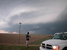
The supercell that would go on to produce a tornado near Hill City

Tornado southwest of Hill City

Tornado with a nice clear slot

Tornado from a distance(damn dirt roads)

3rd supercell of the day southwest of Hoxie. I am working on a few fantastic HDR shots of this storm and will upload those as soon as I purchase the Photomatix software.

Awesome lightning looking east from Collyer
 The supercell that would go on to produce a tornado near Hill City
 The supercell that would go on to produce a tornado near Hill City
No comments:
Post a Comment