Friday, August 14, 2009

Columbia River Gorge Redoux

Lower Ruckel Creek Falls, Columbia River Gorge, Oregon.

I screwed up the white balance and a few other things so here is a much better version of the original shot!

This waterfall is a pain in the ass to reach. We had to scramble 2 miles up a creek with tons of fallen trees and mosquitos. The trek was well worth it as we were greeted with really nice light. I tried to add to the atmosphere by breathing on the lens to get a little glow in the highlights(thanks to Marc Adamus for the tip!). This is the cliche composition, but I will post the others when I have more time. Goodnight from Manzanita, Oregon!

Thursday, June 18, 2009

6/14/09 Belated Kansas Tornado

This was supposed to be the day before the day but ended up being the day! Our storm really looked like outflow crap but somehow managed to put down a short-lived tube. The tornado was in Haskell County, Ks. 2-3 miles west of the 144/83 intersection. There was no rope out stage. The tornado simply got destroyed by outflow lol! On a strange note, We bagged this tube the day after our obligations with V2 ended. Maybe there was a curse lol!


Casual Local Chase

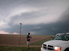
Headed east out of Denver today. I tracked the storm from Watkins to Yuma and had a blast. The storm tried hard to tornado near Otis and dropped some 3 inch hail north of Yuma. This structure early on was very nice, but I ended up with strange color casts from the Polarizer, which I am now ditching. Updates from the rest of the season are coming soon.


Saturday, June 13, 2009

Random Storms

I'm so far behind with photos right now so here are a few random selections. The latter half of the Vortex 2 project has been a blast. Only one tornado, but great storms, structure, and science have made this effort plenty productive. I take comfort in the fact that we need to learn more about non-tornadic storms as well. Tomorrow is the last day of the project so we are hoping for one more tornado obviously. I have many more images that will be spewed fourth randomly over the coming weeks...


Sunday, June 7, 2009

Sand Hills Majesty

A marginal day with a storm that struggled with the cap and anemic surface flow. Probe 8 sampled atomized rain drops, only a few hundred feet south of the hail core. The storm briefly produced epic high based structure and 1.75 inch hail before interacting negatively with an outflow boundary and becoming elongated. We are looking forward to a great chase day tomorrow where boundaries will play a key role in tornadogenesis and associated V2 intercepts.


Regarding today's photography: I tried a new post processing workflow to increase the dynamic range of the scene. It is essentially an un-tonemapped HDR with a simple mask in the foreground. The improper use of a polarizer caused an unnatural color gradient in the sky but I am happy with the global saturation of the image. I will surely be exploring this technique again in the near future.

Scroll down for an epic tornado on the previous chase!

Saturday, June 6, 2009

High Plains Magic!

4 a.m. update lol. Im seeing crap from lack of sleep and I hope these pix are toned ok. Anyway, a quick edit here. Cant go into details obviously but I saw my first Wyoming tornado! V2 got a great dataset and Probe 8 sampled rotating rain curtains just prior to tornadogenesis!