Tuesday, May 29, 2007

5/29 Colorado Chase Report

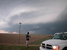
Got pretty much what we expected today. A decent rotating storm before becoming outflow dominant. Started the day in Denver and ended in Denver so thats nice for a change. It wasnt a very productive day for photography as most of my shots were out of focus but I managed to get a few keepers. Woke up to a 5% tornado risk and drove to Limon. A storm went up east of Castle Rock and quickly became tornado warned. We pulled up just as the warning came out and observed a weak wall cloud and decent storm structure. The storm chased us east and quickly crapped out but not before producing an awesome striated shelf cloud. Im looking forward to more Colorado upslope action in the coming months.


A quick HDR shot (I know, I still need to purchase the software but im broke) HDR does wonders for stormscapes but can also make them look fake, this is the original.
The same storm near Simla, just north of Highway 24

Photogenic outflow crap near Genoa


Ditto


Sunday, May 27, 2007

5/21/07 Colorado Chase Report

WOW, what a wonderful surprise. This was simply a travel day with hopes of maybe bagging some decent lightning near the Kansas border. We had nothing better to do so we hung around the storms that fired east of Limon. The storms kicked up a large amount of outflow dust and Jon Merage filmed a decent gustnado somewhere west of Burlington Colorado. A huge line of storms formed as outflows from earlier storms clashed. This new line of storms put the earlier dust farting rain showers to shame. As we approached Burlington, a fantastic sunset began to take shape . The amount of dust in the air created fantastic colors as the sky began to erupt in flame. I was in my element as I have never had a chance to photograph anything as beutiful as this. I shot over 100 images of this sunset, many of them bracketed exposures for HDR combinations. I put together a preliminary HDR shot of this at the hotel and the results are stunning. I will upload HDR shots when I save up the cash to purchase Photomatix. The single exposures by themselves are plenty entertaining. These shots have not been edited aside from resizing.


Fantastic, looking west from northern BurlingtonThis produced a suspicious cone shaped lowering. The beginnings of this can be seen on the right side of the image, just above the watermark.

The HDR version of this is absolutely sexy


5/22/07 Kansas Chase Report

We began the day in colby kansas after a wonderfull surprise storm on the 21st. After a bite to eat and a quick data check, we headed east to WaKeeny. To our delight, we ran into Tim Samaras and Tony Laubach as they were gearing up their video/weather probes for possible deployments. Tim Samaras has a fantastic chase vehicle complete with retractible hail guards and touch screen computer monitors. Soon, the first storms began to erupt on the nose of a dry punch to the southwest. Our targeting was perfect as storms went up within 20 miles of the area. We drove slightly west to the town of Quinter where we observed the genesis of a beutiful supercell. We headed back east on I70 to Collyer where we headed north on dirt roads to track a rotating wall cloud heading towards St. Peter. We had to stop due to muddy dirt roads so we doubled back to the southern storm wich would soon become the dominant supercell of the day. There were very few landmarks on the dirt road network but I can tell you we heard some incredible hail roar somewhere between St. Peter and Hill City. It literally sounded like a giant ice maker in the sky as baseballs were colliding in mid air and pounding the ground. We observed a tornado from quite a distance as we were approaching highway 283 from the west. Upon reaching 283, we entered the circus and followed the storm with a hundred other chasers. The storm began to lose its strength so we blasted west on 24 towards Hoxie where a new supercell had formed. From Hoxie, we went south on 23 towards Grainfield as an impressive striated mesocyclone entered our feild of view. We watched the storm for quite some time before it became completely sheared over and began to take on a linear appearence. We tracked east once again on I70 back to Collyer where we stopped for lightning shots as day turned into night. The tornado warned squall line produced an incredible amount of lightning and provided for some great photo ops. We bunked down in WaKeeny at the best western before heading south to Perryton Texas the next day.


Tim Samaras fastening an adition to one of his probes in WaKeeny The supercell that would go on to produce a tornado near Hill City

Tornado southwest of Hill City


Tornado with a nice clear slot


Tornado from a distance(damn dirt roads)


3rd supercell of the day southwest of Hoxie. I am working on a few fantastic HDR shots of this storm and will upload those as soon as I purchase the Photomatix software.


Awesome lightning looking east from Collyer


Saturday, May 26, 2007

5/23/07 Texas Chase Report

Jon Merage and I saw two very nice supercells in Lipscomb and Hemphill county Texas along with hundreds of other chasers. Both storms were riding the warm front where tornado potential was maximized. We observed several funnels but no tornadoes. ROTATE measured a weak circulation near the time of the first photo but it was rainwrapped. At one point, we were observing the storm on a turnoff when the DOW, TIV, and the whole ROTATE convoy pulled up in the same lot. We got upclose and personal with the TIV as it deployed its hydrolic arms to brace its self for a high wind/tornado event. The whole spectacle was distracting and we soon found our selves sampling the core where we observed strong wind and quarter sized hail. We managed to get out of the core just in time to see the storm become completely outflow dominant. A new supercell had formed to the south near Canadian Texas and we raced to catch up with it before dark. Upond reaching the storm after dark, we observed amazing lightning and a huge striated bell shaped meso. We got sandblasted while taking lightning shots and drove to Canyon Texas where we bedded down for the night.


The core that would soon overtake us Meso earlier in the day

(TIV) Tornado Intercept Vehicle


Striated mothership north of Canadien Texas


Huge Meso, I wish it was daytime!!!


Tuesday, May 22, 2007

Post #30 chasing Kansas today

Jon Merage and I headed out from Denver yesterday and were treated to a nice surprise near Burlington Colorado. What was a crappy linear mess exploded into a squall with a beutiful striated shelf cloud. We observed a shortlived cone funnel aloft and some brief gustnadoes but nothing really tonadic. I shot mainly bracketed exposures in hopes of capturing some good HDR stuff and I was very happy with the results (pics coming soon). We are sitting in Colby Kansas on the western edge of a 10% risk for tornadoes as highlited by the SPC. We will sit along I7o until initiation.

Monday, May 21, 2007

Post #29 First HDR Attempts/chasing today and tommorow

These shots were created by combining 3 shots of the same image at diffrent exposure levels. I downloaded the Photomatix software to check it out and I like what I see so far. I have not bought the program as of yet so it places the Photomatix watermark on my images. These shots are all handheld which is not recomended for combining bracketed exposures. Jon Merage and I will be chasing a marginal setup in Eastern Colorado today and we will chase south-central Kansas tommorow. SPC is mentioning strong tornadoes in their new day 2 outlook which is suprising. I dont think this will pan out like april 23-24 and may 4-5 but I think we will have a decent shot at some naders.


This is my living room. I attempted to make the colors as natrual as possible but it didnt really work. The shot is rather soft due to camera shake over the 3 seperate exposures. I have to pay $100 to get the watermark off of there. I think it may be worth the investment.
This is looking west from my backdoor. Once again, shot is soft from camera shake and misalignment over 3 exposures.


Tuesday, May 8, 2007

Post #28 Pics from 5/4-5/6

Finially, some decent lightning. This was slightly blown out in the middle due to the intensity of the discharge so I had to adjust the exposure with software. 5/5 This shot is pretty perfect aside from that darn telephone pole. 5/5

This is the closest we came to a tornado the whole time. This is a wall cloud associated with the squall line in southern Kansas on 5/6.


Mammatus after the squall completely crapped out (near Witchita). 5/6
This was taken as we were being pulled over. We were hauling ass to catch up to this storm and payed the price. The storm went on to produce tornadoes near Phillipsburg Kansas. We caught up with the storm near Smith Center after dark but observed no tornadoes. We hunkered down in Bellevile Kansas with a close eye on the rader as we were surrounded by tornadic supercells. The Greensburg storm approached our position around 4 in the morning and woke me up with a n insane lightning show. I watched a weak meso pass our location just to the east on the radar and quickly got back to bed. This was a pretty freaky night. 5/4


Post #27 Report 5/4-5/6 KS/OK

Before I begin, my thoughts and best wishes are with the residents of Greensburg, Kansas. An EF-5 tornado ravaged the city of Greensburg killing 9 and injuring several more. The town is completely destroyed and uninhabitable. Countless lives were saved thanks to the advance tornado emergency that was issued by the NWS DDC 20 minutes before the mile wide tornado arrived. The emergency agencies in Kansas responded rapidly and effectively as they converged on the city. Many lives were likely also spared by the swift rescue efforts. Jon Merage and I stayed in Greensburg back on the night of 4/23 after the Protection, Ks tornadoes. The hotel desk clerk, a wonderfully friendly man accomidated us and even gave us a jump start when our car battery died. I was troubled to see this man in an interview on CNN lastnight. He lost everything but his life in this disaster. This situation has left me contemplating ways that I can help. Aside from donating food/clothing, I am unsure how else I may help especially considering my broke college student lifestyle.

Ok, aside from the horrific disaster, there was some tornado chasing during all of this. Jon and I were out from friday through monday. Nothing seemed to work out well during this chase. We saw no tornadoes, got pulled over, the car broke down, drove nearly 2000 miles, spent lots of money, and to make things worse, Greensburg, KS was destroyed by a huge tornado. Many of the tornadoes happened after dark so that couldnt be helped but our targeting was horrible. We were constantly intercepting storms from the north or playing catchup the whole time. Fortunately, Im still in good spirits over our chases of 4/23 and 4/24 otherwise, I would be completely depressed. I did finally manage to get some real awesome lightning shots which will be coming as soon as I get done with my finals today. Looks like some quiet time is coming which will limit chasing prospects. It will work out because I really need to save up some cash for chasing in late May and June. Back to studying for now, lightning shots coming soon.

Friday, May 4, 2007

Post #25 HUGE Weekend Chase!!!!!

What can I say, tommorow is going to be HUGE. I really hope this is a glitch but 850mb winds of 60 kts? INSANE!!! CAPE in excess of 4000 j/kg INSANE!!! We will be targeting the northeastern corner of the dryline bulge somewhere near Ness City Kansas. The tornado threat will persist throughout the night on friday. Saturday also looks INSANE!! for just east of fridays action. Significant tornadoes are likely, hopefully these will not affect any populated areas. Jon Merage and I will possibly be chasing through monday, Updates to come.

What? That is sick CAPE Convective Precip northeast of the dryline bulge!!


Tuesday, May 1, 2007

Post #25 Littleton non-severe storm

We had a few storms around the Denver area this afternoon, one of which drew a severe thunderstorm warning. I observed very small hail on the MSCD campus around 4 p.m. I observed this storm near my house in western Littleton at about 6:30. Non-severe but very ominous looking and photogenic. The storm was producing occasional cloud to ground lightning but that quickly ceased near sunset to my dismay. These diurnaly driven storms are making me crazy!!! I will hold out hopes for tommorow's action as the Denver AFD is mentioning possible tornadoes.


All images from the intersection of Kipling and Ken Caryl Ave looking south.