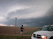
Ok well we started the day in some crappy town west of Pratt Kansas. It was a tricky forecast and we ended up all the way down in Enid Oklahoma before we realized we needed to get back north to the area that had not been raped by the squall line earlier in the day. Jon Merage noticed a boundary on the radar and storms soon began to fire along it. We targited the southern end in hopes that the whole thing wouldnt line out. Boy was our timing perfect. Our total mileage from the week was over 2500 miles!!!! I drove all but the last 100 miles or so after accepting defeat from complete exhaustion. Please keep in mind, these are preliminary reports.UPDATES TO COME!!!
Funnel Somewhere near Nickerson Kansas in Reno County.
Tornado on the ground south of Nickerson
Debris still visible. For some reason, these tornadoes never really got full condensation funnels all the way to the ground. Something was missing for sure as these tornadoes appeared modest in comparison to the previous day.
Thursday, April 26, 2007
Post #22 4/23/07 Chase Report
Started the day out in Childress Texas. We headed north towards Perryton Texas with the warmfront/dryline intersection in mind. Headed east from Perryton into Oklahoma towards Buffalo, then north into Kansas toward Sitca and east agin to Protection Kansas. Got somewhere between 3 and 5 tornadoes, have to check the video. Extended report COMING SOON!!
Early on in the storm, looking north. Funnel cloud looking north, somewhere around Buffalo I think.
Monday, April 16, 2007
Post #19 Probable weekend chase!!!
This weekend's potetential severe weather event has me pretty stoked. Oviously the weekend timing is convenient considering my work and school schedule.
A 35-40 Kt LLJ gets cranking with backing winds near the dryline. Hopefully the surface winds will back more than what is depicted here. The 700mb temps show the cap eroding nicely.
The GFS shows a decent toungue of surface based CAPE. I would like to see this increased but 2000 sb CAPE would be good enough to feed some solid updrafts.
A reasonably sharp dryline is depicted here with solid mid 50's dewpoints to the east.
I suppose this is a good sign when the GFS breaks out precip along the dryline 132 hours out.
Obviously things could change quite a bit so im not going gung ho as of yet. At this point, I would target anywhere between Hays and Dodge City Kansas. Hopefully, things will back up to the west just a bit. I would love to think that this event will unfold like the tornado outbreak on 3/28 but with more tornadoes up north before dark. On a more current note, storms are possible along the I-25 corridor tonight. I will be heading out after dark in search of hopefully some decent lightning. I am also picking up a sigma telephoto lens tonight to hold me over untill I can afford that Canon IS. Its only 70$ used so I dont see how I could go wrong.Thursday, April 12, 2007
Post #18 Finally got my cable release
Well I finally got that hard to find cable release as well as a window mount tripod head with a quick release. The guy at the camera shop reccomended that I try the Pentax cable release on my canon and somehow it worked, autofocus and everything. So, I ended up getting both items for under 60$ so I guess I did pretty good. Its really just down to getting a telephoto lens and a battery grip and my setup will be complete for a while. The shots below are just messing around. I focused too close so the background is blurred slightly but they came out pretty cool regardless.
Sunday, April 8, 2007
Post #17 more 50mm fun
My Father and I decided to go shoot some pool so I figured it would be fun to experement with that plastic 50mm lens that I have. After arriving at the bar, i kicked my self for forgetting a tripod. I did end up with some ok images from 0.5 to 2 second handheld shots but there is some obvious camera shake. I am going to try this again with a tripod for sure.
Subscribe to:
Posts (Atom)